http://gis.rchss.sinica.edu.tw/qgis/?p=4234
https://geoservice.dlr.de/web/dataguide/tdm90/

The TanDEM-X 90m Digital Elevation Model
Introduction
TanDEM-X (TerraSAR-X add-on for Digital Elevation Measurements) is an Earth observation radar mission that consists of a SAR interferometer built by two almost identical satellites flying in close formation. With a typical separation between the satellites of 120m to 500m a global Digital Elevation Model (DEM) has been generated.
Main objective of the TanDEM-X mission is to create a precise 3D map of the Earth's land surfaces that is homogeneous in quality and unprecedented in accuracy. The data acquisition was completed in January 2015 and production of the global DEM was completed in September 2016. The absolute height error is with about 1m an order of magnitude below the 10m requirement.
The TanDEM-X 90m DEM offered here for download is a product derived from the global Digital Elevation Model (DEM) with a 0.4arcsec (12m) posting, and has a reduced pixel spacing of 3 arcseconds (arsec), which corresponds to approximately 90m at the equator. It covers with 150 Mio sqkm all Earth’s landmasses from pole to pole.
Applications
- Earth sciences (geology, glaciology, oceanography, meteorology, hydrology)
- Environmental research, land use, vegetation monitoring, urban and infrastructure planning
- Cartography, navigation, logistics, crisis management, defence and security
Some Numbers:
Number of DEM products: 19389
Size of the global data set, zipped (including all annotations): 253 GB
Size of the global data set, unzipped (including all annotations): 534 GB
Size of all DEM raster files (unzipped, without annotations or meta data): 93.8 GB
Number of DEM products: 19389
Size of the global data set, zipped (including all annotations): 253 GB
Size of the global data set, unzipped (including all annotations): 534 GB
Size of all DEM raster files (unzipped, without annotations or meta data): 93.8 GB
This information page gives an overview about the basic products specifications of the TanDEM-X DEM product, about the TanDEM-X mission, explains how to register, and how to download the TanDEM-X 90m data sets, which license terms for the use of the data have to be considered, and comprises basic compatibility issues, which might arise when other global or local height data sets are planned to be compared or to be combined with the TanDEM-X DEM products. At the end of this page suggestions for further readings and literature, a FAQ, tips for software tools, and contact information can be found.
Overview of the TanDEM-X DEM Product Specification
The following chapter gives a short overview about the essential products specifications of TanDEM-X DEM products. The TanDEM-X 90m DEM product offered for download follows in the most aspects this specification. DLR recommends for in-depth reading the download of the latest TanDEM-X DEM specification document, which can be found here:
TanDEM-X DEM Product Specification
TanDEM-X DEM Product Specification
The TanDEM-X 90m (3 arcsec) DEM is a product variant of the 12m (0.4 arcsec) DEM product in Version 1.0. As such it has the following basic characteristics:
- The TanDEM-X DEM represents a Digital Surface Model (DSM), means it does not represent the bare earth surface, when e.g. vegetation or man-made objects are present.
- The current release is the non-edited version, which means each TanDEM-X DEM product can contain:
- Processing artefacts and outliers
- Noisy areas (e.g. water surfaces, steep slopes, dense vegetation) with at least partly unreliable height values. Water surfaces (or other noisy surfaces) are not filtered, delineated or flattened!
- Voids or Invalid Data, areas with missing height values, e.g. when from the existing RawDEM data set no valid height value could be calculated, or where all acquisition attempts failed. No void filling or interpolation has been applied to the current TanDEM-X data DEM sets!
- The horizontal as well as the vertical reference system (horizontal & vertical datum) of TanDEM-X DEM products is the WGS84 ellipsoid (realization G1150). The heights of the TanDEM-X DEM products are ellipsoidal heights!
DEM Accuracy
The global accuracy goals for the TanDEM-X 12m (0.4 arcsec) DEM products have been defined as follows:
- The Absolute horizontal accuracy, expressed as a circular error at 90% confidence level (CE90): below 10m
- The Absolute vertical accuracy expressed as a linear error at 90% confidence level (LE90): below 10m
- The Relative vertical accuracy expressed as linear errors at 90% confidence level (LE90) for slopes at or below 20% at 2m, and for slopes above 20% at 4m.
Validation results (see [R02] and [R03] in the literature chapter) have shown, that the performance goal for the 12m DEM have been reached, and that the absolute vertical error and the relative vertical error are both well below the specified performance goal. Due to spatial averaging will the relative vertical error of the TanDEM-X 90m (3arcsec) product be much better than the relative vertical error of the TanDEM-X 12m (0.4 arcsec) product.
Product File Structure
The TanDEM-X 90m DEM product is delivered in a compressed ZIP (*zip) format. Each zip file contains a main folder, which contains basically the meta data of the product in XML (*.xml) format. In the main folder there are 3 subfolders:
- DEM: The DEM raster layer
- AUXFILES: The 7 information raster layer
- PREVIEW: All quicklook raster and KML files
The 7 additional information layers are::
- Height Error Map (HEM)
- Amplitude Mosaic (AMP) representing the mean value
- Amplitude Mosaic (AM2) representing the minimum value
- Water Indication Mask (WAM)
- Coverage Map (COV)
- Consistency Mask (COM)
- Layover and Shadow Mask (LSM), based on SRTM C-band and Globe DEM data
The DEM as well as the 7 Information layer are in a GeoTIFF (*.tif) raster format, but with different bit depths and data types. Please note that in contrast to the file naming convention the annotated ModelTiepointTag in the GeoTIFF raster file header refers to the pixel center in the northwest corner, which corresponds to the ‘RasterPixelIsPoint’ raster space definition (value of the tag GTRasterTypeGeoKey is set to ‘2’) of the GeoTIFF specification.
For the DEM as well as for the 7 information layers quicklooks in a GeoTIFF (*.tif) raster format are provided, associated with a KML file for inspection in Google Earth. Additional quicklook raster files with a legend and a map border in PNG (*.png), but without an associated KML file, are available as well.
The meta data file includes a list of all RawDEM scenes contributing to the final DEM mosaic, with exact acquisition dates and corner coordinates. The polygon outline of all RawDEM scenes is in addition provided by a KML file in the PREVIEW folder.
Naming Convention
The file naming convention of TanDEM-X DEM products refers to the latitude and longitude value of the center of the lower left or southwest corner pixel of a DEM product, but other information is coded in the file base name or folder name as well. The prefix string in the file base name has the general form:
'TDM1_tttt_nn_BbbXxxx_FFF'
And for the main DEM product folder it has the general form:
'TDM1_tttt_nn_BbbXxxx_Vvv_G'
The meaning of the letter codes in particular is given by the follwing table:
'TDM1_tttt_nn_BbbXxxx_FFF'
And for the main DEM product folder it has the general form:
'TDM1_tttt_nn_BbbXxxx_Vvv_G'
The meaning of the letter codes in particular is given by the follwing table:
| Letter | Meaning | Example |
| tttt | product type, i.e. DEM_, IDEM, FDEM, HDEM | DEM_ |
| nn | Spacing, 04: original spacing, 10: reduced to 1-arcsecond grid, 30: reduced to 3-arcsecond grid | 30 (read 3arcsec for the 90m DEM) |
| B | “N” if the center of southwest corner pixel of a tile is on the equator or north of it. “S” if it is south of the equator. | N |
| bb | 2-digit latitude value of the center of the southwest corner pixel of a tile in degrees. | 64 |
| X | “E” if the center of the southwest corner pixel of a tile is in the eastern hemisphere, “W” otherwise. If the center of the southwest pixel of the tile is exactly at 0° longitude, this is “E”. If the center of the southwest corner pixel is exactly at ±180° longitude, this is “W”. | W |
| xxx | 3-digit longitude value of the center of the southwest corner of a tile in degrees. | 018 |
| FFF | File type, will be one of the following: DEM (for the elevation data) HEM (for the height error map) AMP (for the mean amplitude mosaic) AM2 (for the minimum amplitude mosaic) WAM (for the water indication mask) COV (for coverage map) COM (for the consistency mask) LSM (for the layover and shadow mask) IPM (for the interpolation mask) (for IDEM products only) | HEM |
| Vvv | Production version of a DEM product | V01 |
| G | Coverage Flag P: Preliminary C: Complete | C |
Background Value of the DEM Layer
Missing height values (voids and data gaps) receive the background value –32767.0
Product Tile Extent
All DEM products between 0° - 60° North/South latitude have a file extent of 1° in latitude direction and 1° in longitude direction. Between 60° - 80° North/South latitudes a product has an extent of 1° x 2°, between 80° - 90° North/South latitudes a product tile has an extent of 1° x 4°.
Pixel Spacing
The pixel spacing for the TanDEM-X 90m DEM product in latitude direction towards the poles is constant at 3 arcsec, but the pixel spacing in longitudinal directions is not. Instead 6 different zones with different longitudinal pixel spacing ranging from 3 arcsec to 30arcsec are defined for both the Northern and Southern hemisphere. In a metric scale the latitude pixel spacing varies only slightly due to the ellipsoid flattening between 92.78m at the equator and 92.50m at the pole, while for the longitudinal pixel spacing larger differences are present.
| ||||||||||||||||||||||||||||||||
| Equator | ||||||||||||||||||||||||||||||||
| ||||||||||||||||||||||||||||||||
| South Pole |
Further Information about the TanDEM-X Mission
Parties Involved
German Aerospace Center (DLR)
Airbus Defence & Space GmbH
GFZ German Research Centre for Geosciences
Airbus Defence & Space GmbH
GFZ German Research Centre for Geosciences
Facts and Figures
- Two X-band SAR satellites, built by Airbus DS, 1.3 tons each, length: 5 m long, diameter: 2.4 m, flying in close formation
- Active phased array antenna, size: 4.8 m × 70 cm, electronic beam steering capability, radar frequency: 9.65 GHz, H and V polarisation
- Satellite control, data management, reception, processing and calibration by DLR
- TanDEM-X DEM: Absolute height accuracy ~1 m, horizontal sampling variants: 12 m, 30 m, 90 m
The TanDEM-X mission (TerraSAR-X add-on for Digital Elevation Measurement) opened a new era of spaceborne radar remote sensing. It is the world's first bistatic SAR mission to be formed with two almost identical satellites flying in a closely controlled formation with typical distances between 250 and 500 meters. The main objective of the mission is to generate a consistent global digital elevation model with unprecedented accuracy. TanDEM-X also offers a highly reconfigurable platform for demonstrating new SAR techniques and applications. The TanDEM-X mission measures the entire land surface of the earth that is 150 million square kilometers, several times completely. In addition to the high horizontal resolution according to a horizontal sampling of 12 meters and the high vertical accuracy, the elevation model created with the TanDEM-X and TerraSAR-X satellites has another outstanding advantage: It is consistently homogeneous and thus the basis for a uniform map material worldwide. The Earth's surface is a very dynamic system when analyzed at this level of accuracy. Not only height changes in glaciers, permafrost regions and forests but also agricultural activities and changes in infrastructure leave clear marks in the DEM. Therefore, an additional complete acquisition of the Earth's landmass is carried out from September 2017 until end of 2019 to provide an independent unique DEM-data set. The resulting product, called "Change DEM" will allow monitoring topographic changes on a global scale.
Access to the TanDEM-X 90m DEM Data Sets
To get access to the products a self-registration is necessary with your personal address details. The e-mail address provided is also the user name for accessing the download interfaces.
For the final order account generation you have to agree during the registration process to the Privacy Policy and the User License, otherwise the account will not be generated, and downloading data will not be possible. You can find the Privacy Policy and the User License as PDF document here:
Privacy Policy
User License
General Workflow
- Register on the Registration page to get a user name (= your email address) and password. Use a valid email address and complete and submit the registration form.
- Receive an email after initial registration with a link to a confirmation page.
- Follow the link in the email and verify the account’s user name and password by submitting the confirmation form. This step cannot be skipped!
- Configure your FTP client for bulk downloads, or use the map driven interface to download single products for smaller regions.
How to Register
- Go to https://sso.eoc.dlr.de/pwm-tdmdem90
- Click on "New User Registration" (below the login mask) to reach the registration form
- Complete the form. Note: the e-mail address is also your user name
- Click on "Create", and the verification form appears
- An e-mail with a confirmation link will be sent to your email account. Please click on it and copy the code from the email into the registration form. Please make sure that your e-mail program didn't block the confirmation e-mail.
- A forwarding to the data protection declaration and the license conditions takes place. After their acceptance, the account is configured automatically.
- An additional email containing the license terms and the privacy policy will be sent.
Downloading Products
For the downloading of TanDEM-X 90m DEM products three options (either via HTTPS or FTPES), are available, depending on your preferences, your machine, your system settings and the amount of data you want to download. Solely encrypted connections are supported and a login with your user name and password (from the self-registration described above) is mandatory; plain HTTP or FTP download methods are not supported.
- Variant A: HTTPS Web browser & map-based interface for selecting individual tiles.
- Variant B: FTP/FTPES, recommended for larger quantities or the whole data set, by using an FTP client
- Variant C: HTTPS Web browser interface for selecting individual tiles directly by browsing the directory structure
Variant A – Using a HTTPS Web browser & map-based interface
This download option is recommended for users who wish to download a few products and who prefer the usage of a map driven interface for the selection of the products. For downloading larger areas or the complete global data set, we recommend the usage of an FTP client (see Variant B below).
This download option is recommended for users who wish to download a few products and who prefer the usage of a map driven interface for the selection of the products. For downloading larger areas or the complete global data set, we recommend the usage of an FTP client (see Variant B below).
- Go to the login form at URL:
https://sso.eoc.dlr.de/pwm-tdmdem90
Login by entering your username and password you have registered with, and submit the login form - Enter the URL of the map interface in a new web browser tab:
https://download.geoservice.dlr.de/TDM90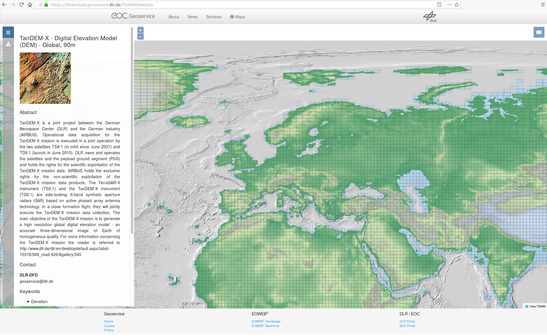 The page will appear with basic information about the TanDEM-X mission on the left and the map interface (showing a color coded version of the TanDEM-X global DEM) with the polygon outline for each individual DEM tile on the right. You can alter the map layer(s) shown in the map with the icon in the top right corner above the map canvas. Zoom to your region of interest, if needed.
 - Select the desired products (=left-click with the mouse on the corresponding tile). The name of the product appears in a list on the left side.
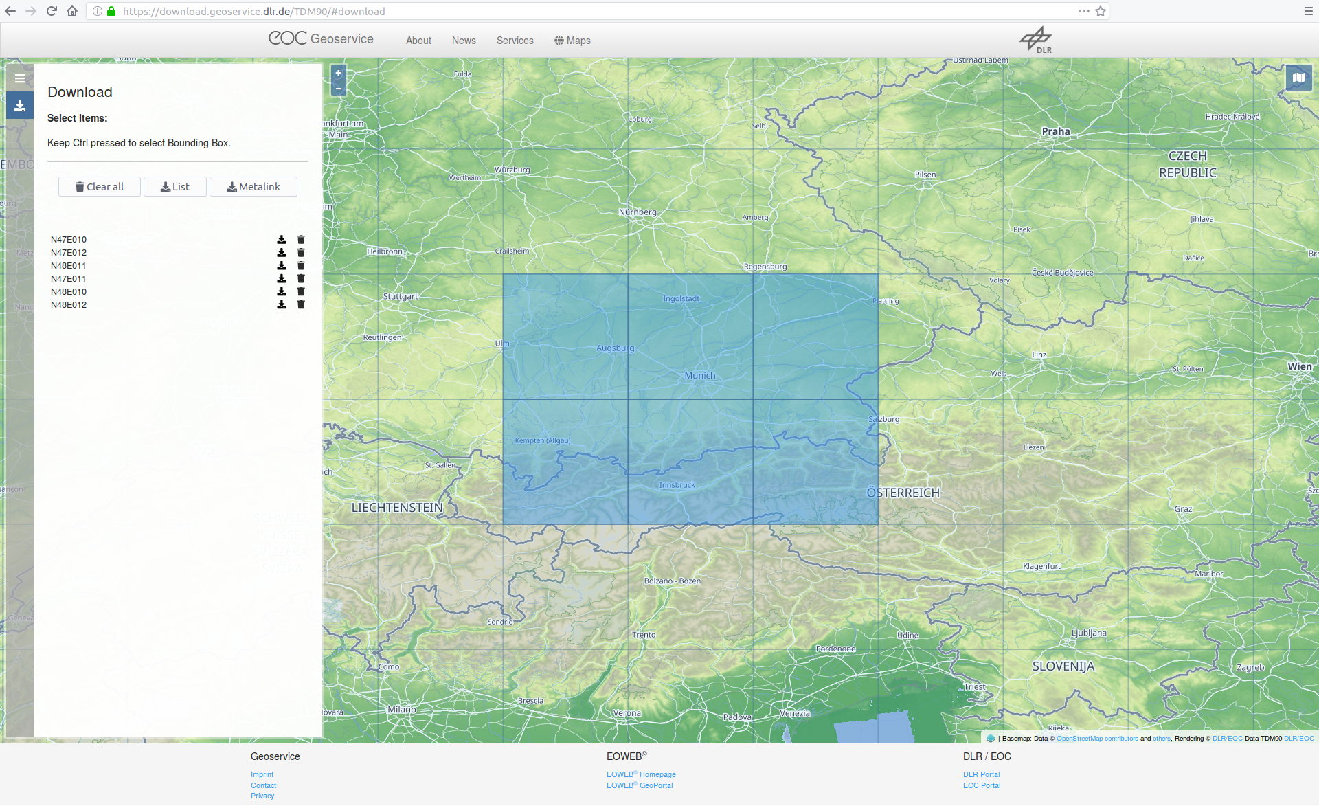 Alternatively you can also draw a search rectangle in order to download the products for a larger region of interest. Press the CTLR key on your keyboard while left-clicking with the mouse on a point and drag and draw the rectangle on the map. The search rectangle will be closed and the products will be selected, when you release the mouse button. Selected products appear on the left side of the page. You can remove single items from the list by selecting the trash bin icon associated which each item.
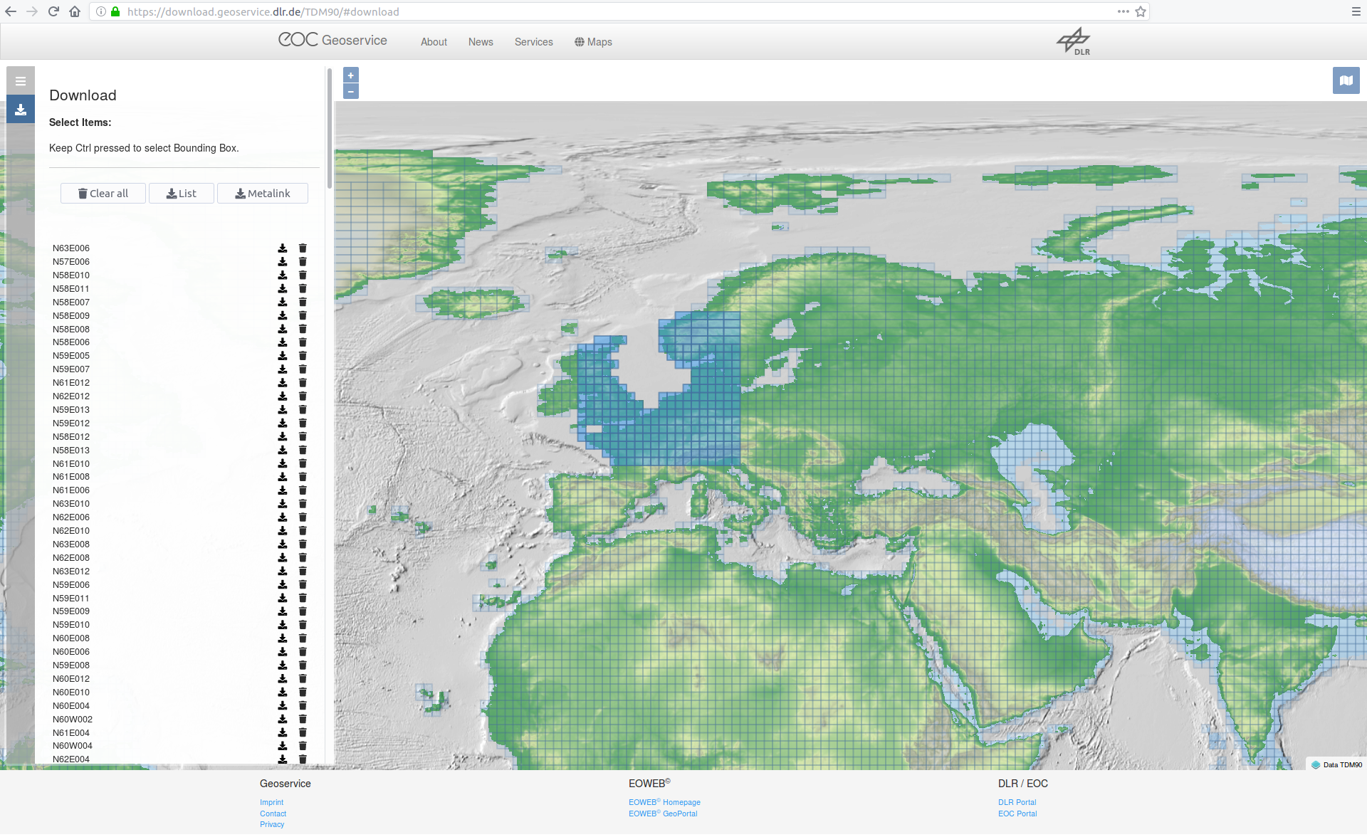
- After the desired products have been selected, they can be saved on your computer file by file by clicking on the download icon associated to each item. If you are not logged in to this point, then the login page will be shown.
- Optional: If you want to automate the download of a larger list of files you can select the ‘List’ icon to save the download list to an ASCII text file (with an absolute pathname for each file per line), or you can select the metalink icon to save the file list to an XML-like metalink file.
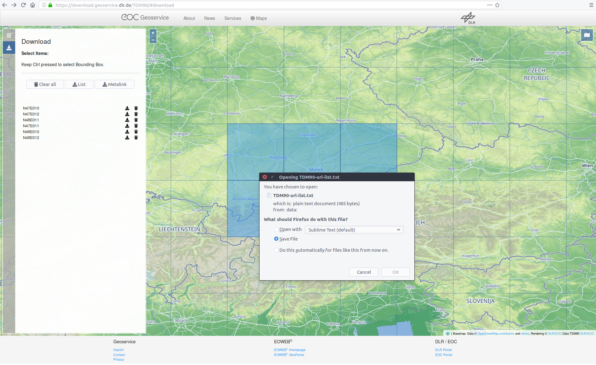 The ASCII file list can then be fed to a command line FTP client (e.g. wget or cURL, which are included in numerous Linux distributions), or to a download manager (e.g. aria2). The following code examples will illustrate the usage of those command line tools. The final line of code might need some adaptions with respect to individual system settings (e.g. whether a proxy is needed), but might serve as a starting point.Suppose you have saved the list to the name ‘TDM90mDEM-url-list.txt’ to your current working directory and the download directory will be the current working directory as well, then the wget command would be the following one-liner:
wget -i TDM90mDEM-url-list.txt --auth-no-challenge --user='username' --ask-passwordThe cURL command line would be:
curl $(printf ' -O %s' $(or, alternativelyxargs -a TDM90mDEM-url-list.txt -L1 curl -O -u 'username:password'The aria2 command line would be:aria2c -i TDM90mDEM-url-list.txt --http-user 'username' --http-passwd 'password'The metalink XML file can be fed to a download manager tool (e.g. aria2). Suppose you have saved the metalink to the file name ‘TDM90.meta4’ in your current working directory, then the command line for aria2 would be:aria2c -M TDM90.meta4 --http-user 'username' --http-passwd 'password'
Variant B: Using an FTP client program
As an alternative can the DEM data sets also be downloaded with a dedicated FTP client program.
It is important to note that the connection to the DLR FTP server can only be established, if the FTP client program supports FTPES (explicit TLS/SSL encryption). All other methods will fail and are not supported.
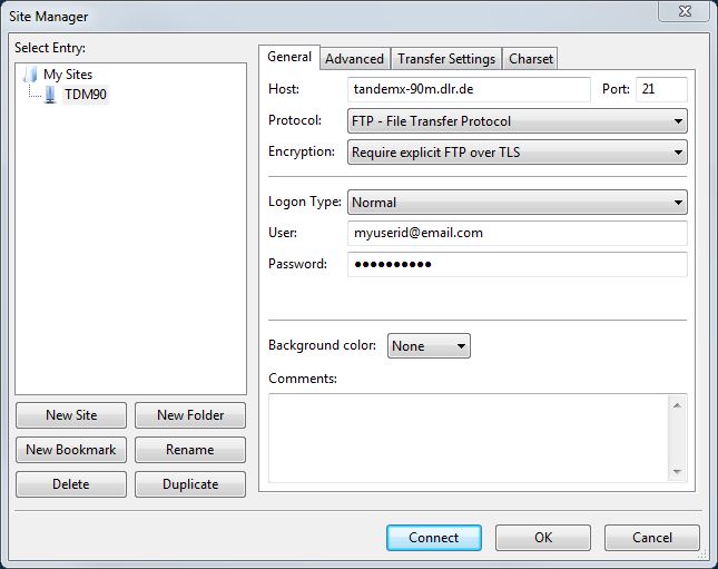
Please use the following setting when configuring your FTP client:
- FTP Server-Address: ftpes://tandemx-90m.dlr.de
- Port: 21 (the standard port for explicit TLS/SSL connections)
- FTP method/servertype: FTPES over explicit TLS/SSL
- User name: your username (= the email address you have used for the registration)
- Password: your password (= the password you have used for the registration)
- Passive mode needs to be enabled!
An FTP freeware client with a graphical user interface which supports the FTPES encyption method is e.g. FileZilla (administrator rights needed for installation). An example how to configure the FileZilla site manager (from menu: File -> Site Manager -> New Site) with the instructions above is shown below. The connection to the FTP server can be started by selecting the ‘Connect’ button.
Directory Structure on the FTP Server:
The main directory structure on the FTP server is the following:
DEM: In this directory all available TanDEM-X 90m DEM products including all metadata, information layer and preview files (quicklooks) are stored in a compressed ZIP (*.zip) format. Go here, if you need the complete data set for a certain DEM tile.
ANNOTATION: In this directory only some selected DEM quicklooks, associated KML files, and the main meta data XML file is provided for each DEM product. All those files are included in the original *.zip file in the DEM directory and do not need to be downloaded separately if the data is planned to be downloaded from the DEM directory.
KMZ: In this directory for all DEM products Google Earth compatible KMZ (image overlay) files of the quicklooks are provided. The KMZ contains the raster and the KML in a compressed format. The underlying original quicklook raster has been converted from the TIF format towards a PNG format.
Hierarchical Directory Structure
The 3 main directories DEM, ANNOTATION and the KMZ contain subdirectories. The first subdirectory level is based on latitudes, one separate directory for each latitude value; each latitude subdirectory is subdivided into further subdirectories for the longitude spaced by 10 degree. Only subdirectories actually containing DEM tiles are visible.
Example: the directory ‘/DEM/N49/E010’ contains the following 10 zip files:
TDM1_DEM__30_N49E010.zip
TDM1_DEM__30_N49E011.zip
TDM1_DEM__30_N49E012.zip
TDM1_DEM__30_N49E013.zip
TDM1_DEM__30_N49E014.zip
TDM1_DEM__30_N49E015.zip
TDM1_DEM__30_N49E016.zip
TDM1_DEM__30_N49E017.zip
TDM1_DEM__30_N49E018.zip
TDM1_DEM__30_N49E019.zip
TDM1_DEM__30_N49E011.zip
TDM1_DEM__30_N49E012.zip
TDM1_DEM__30_N49E013.zip
TDM1_DEM__30_N49E014.zip
TDM1_DEM__30_N49E015.zip
TDM1_DEM__30_N49E016.zip
TDM1_DEM__30_N49E017.zip
TDM1_DEM__30_N49E018.zip
TDM1_DEM__30_N49E019.zip
Variant C: Using a HTTPS Web browser and browsing the directories
The files can be also accessed via HTTPS by entering the following URL path into your web browser:
https://download.geoservice.dlr.de/TDM90/files/
https://download.geoservice.dlr.de/TDM90/files/
If you are not logged-in, the login page will appear first. Please use the username and password you have used for the registration to get access to the download directories. Single files can be downloaded by clicking on the files. The hierarchical directory structure is the same as given by the FTP option (see Variant B), but only the zipped DEM products can be acessed (and not the ANNOTATION or KMZ directories).
Compatibility Issues to other Height Data Sets
For a joint processing with other height data the compatibility of the horizontal as well as the vertical reference has to be assured, otherwise positional and/or vertical offsets with a magnitude up to decameter range might show up. Hence, a transformation or even a chain of transformations towards compatibility is needed in the most cases, whose complexity level depends on the target system, and starts with the question in which horizontal (=positional) AND vertical (=height) reference system is the data set in. An exact knowledge of both reference systems is mandatory.
Ellipsoidal Height
Ellipsoidal height is purely geometric definition of height and is the distance measured along the normal of a reference ellipsoid to the point on the Earth surface. The vertical datum of the TanDEM-X 90m DEM data set is the WGS84 ellipsoid, hence the height values given by the TanDEM-X 90m DEM data sets are heights above the ellipsoid or ellipsoidal heights. If the ellipsoid of the reference height data sets is not the WGS84 ellipsoid, which is mostly true for the majority of national height data sets, then a datum transformation in three-dimensional Cartesian space is required. For small- and mid-scale mapping application e.g. a 7 parameter Helmert transformation (3 translation parameters, 3 rotation parameters, 1 scale factor) might be sufficient and is mostly integrated into common GIS software. For higher accuracy levels please contact your cadastral authority to obtain improved parameter sets for this task.
Orthometric Height
Orthometric height is the distance along the plump line from a surface point to a reference geoid. The geoid is a surface based on the gravity potential and derived from gravity measurements, but assumptions about the Earth mass density distribution are required. The mean sea level (MSL) approximates best the geoid.
Please note in this context that the height values represented by other freely available global/near global height data sets (SRTM 1-arcsec, ASTER GDEM2, ALOS World 3D) are referenced to a geoid instead of an ellipsoid, and their height values have to be considered as orthometric heights. The relation between ellipsoidal height and orthometric height is given by:
h = H + N
where
h: Ellipsoidal Height
H: Orthometric Height
N: Geoid-Height
h: Ellipsoidal Height
H: Orthometric Height
N: Geoid-Height
The geoid model used for the aforementioned global/near global height data sets is the global EGM96 geoid, which can be easily found and downloaded by a global internet search. If the pixel spacing of DEM and geoid model is not equal, bilinear interpolation should be used for resampling of geoid undulations. The conversion from ellipsoidal to orthometric height or vice versa is simple math given the formula above.
Normal Height
The alternative concept of normal height does not use any hypothesis about the Earth mass density distribution, but refers in addition to the local reference ellipsoid, and originates historically from terrestrial levelling practice before the rise of the satellite geodesy age and is widely used in European countries. The theoretical reference plane related to normal heights is called quasi-geoid. The relation between ellipsoidal heights and normal heights is given by the formula:
h = HN + ζ
where
| h: | Ellipsoidal Height |
| HN: | Normal Height |
| ζ: | Quasi-Geoid-Height |
The difference between the orthometric height and the normal height of a point is not dramatic and is usually in the range of some centimeters to decimeters, but can also reach 1.5m. Sources for adequate geoid or pseudogeoid models are usual the national catastral authorities (e.g. in Germany the Federal Agency for Cartography and Geodesy, BKG).
Frequently Asked Questions
Coming Soon...
Further Reading: Literature/Weblinks
Citation of one of the two listed papers [R02] and [R03] is adequate if you use the TanDEM-X DEM.
Literature
[R01] Grohmann, C. H. (2018): Evaluation of TanDEM-X DEMs on selected Brazilian sites: Comparison with SRTM, ASTER GDEM and ALOS AW3D30
Remote Sensing of Environment, Vol. 212, pp. 121-133.
Remote Sensing of Environment, Vol. 212, pp. 121-133.
[R02] Wessel, B., Huber, M., Wohlfart, C., Marschalk, U., Kosmann, D., Roth, A.(2018): Accuracy Assessment of the Global TanDEM-X Digital Elevation Model with GPS Data.
ISPRS Journal of Photogrammetry and Remote Sensing. Vol. 139, pp. 171-182.
ISPRS Journal of Photogrammetry and Remote Sensing. Vol. 139, pp. 171-182.
[R03] Rizzoli, P., Martone, M., Gonzalez, C., Wecklich, C., Borla Tridon, D., Bräutigam, B., Bachmann, M., Schulze, D., Fritz, T., Huber, M., Wessel, B., Krieger, G., Zink, M., and Moreira, A. (2017): Generation and performance assessment of the global TanDEM-X digital elevation model.
ISPRS Journal of Photogrammetry and Remote Sensing, Vol 132, pp. 119-139.
ISPRS Journal of Photogrammetry and Remote Sensing, Vol 132, pp. 119-139.
[R04] Wessel, B. (2016): TanDEM-X Ground Segment – DEM Products Specification Document. EOC, DLR, Oberpfaffenhofen, Germany, Public Document TD-GS-PS-0021, Issue 3.2, 2016. [Online]. Available: https://tandemx-science.dlr.de/
[R05] Zink, M., Bachmann, M., Bräutigam, B., Fritz, T., Hajnsek, I., Krieger, G., Moreira, A., Wessel, B., TanDEM X: The New Global DEM Takes Shape, IEEE Geoscience and Remote Sensing Magazine (GRSM), 2(2), pp. 8-23, 2014.
[R06] Krieger, G., Zink, M., Bachmann, M., Bräutigam, B., Schulze, D., Martone, M., Rizzoli, P., Steinbrecher, U., Antony, J.W., De Zan, F., Hajnsek, I., Papathanassiou, K., Kugler, F., Rodriguez Cassola, M., Younis, M., Baumgartner, S., López-Dekker, P., Prats, P., Moreira, A., 2013. TanDEM-X: a radar interferometer with two formation-flying satellites. Acta Astronaut. 89, 83-98. August-September.
[R07] Krieger, G., Moreira, A., Fiedler, H., Hajnsek, I., Werner, M., Younis, M., Zink, M., 2007. TanDEM-X: a satellite formation for high resolution SAR interferometry. IEEE Trans. Geosci. Rem. Sens. 45 (11), 3317-3341.
Weblinks
Further information, as well as proposal web forms for the higher resolution DEM products (12m & 30m DEM product) at:
https://tandemx-science.dlr.de
https://tandemx-science.dlr.de
Main NGA page on Earth gravity models (e.g. EGM96, EGM2008):
http://earth-info.nga.mil/GandG/update/index.php?action=home
http://earth-info.nga.mil/GandG/update/index.php?action=home
vdatum: A freeware software tool with a graphical user interface for vertical (and horizontal) grid transformations, provided by the United States National Oceanic and Atmospheric Administration (NOAA):
https://vdatum.noaa.gov/welcome.html
https://vdatum.noaa.gov/welcome.html
License: Terms of Use
Every user intending to download TanDEM-X 90m DEM products has to accept during the registration process the user license. The license is exclusively granted for scientific utilization of the TanDEM-X 90m DEM data set provided by DLR.
You can find a PDF document download here: User Licence for the Utilization of the TanDEM-X 90m DEM Data Products for Scientific Use
Or you can read the original text here:
User Licence for the Utilization of the TanDEM-X 90m DEM Data Products for Scientific Use
Hereby a licence for the use of the TanDEM-X 90m Digital Elevation data products (short. TanDEM-X 90m DEM or TanDEM-X 90m DEM products) as defined below is granted by the German Aerospace Center (DLR) to the User. This license is free of charge, but exclusively granted for scientific use. A licence for commercial use of the TanDEM-X 90m DEM data products is to be purchased separately.
DEFINITIONS
(1) The TanDEM-X 90m DEM product as described in the DLR TanDEM-X DEM Products Specification Document (TD-GS-PS-0021) was derived from the global TanDEM-X Digital Elevation Model and has a pixel spacing of 3 arcseconds in the latitude direction. The TanDEM-X 90m DEM product contains all data provided on the DLR delivery server, including all supplemental data and metadata.(2) The German Aerospace Center (DLR) is the author and owner of the TanDEM-X 90m DEM. Deutsches Zentrum für Luft- und Raumfahrt e.V. German Aerospace Center (DLR) Linder Höhe 51147 Köln Germany
(3) User is the person named in the registration form as the holder of the user account for downloading the TanDEM-X 90m DEM product(s).
(4) Scientific use is the use of TanDEM-X 90m DEM by public or private research organisations or researchers only for the purpose of obtaining academic research results for their own scientific purposes.
(5) Commercial use is marketing, especially the sale of the TanDEM-X 90m DEM for the purpose of charging a fee or receiving remuneration.
DATA RIGHTS
(1) DLR provides the TanDEM-X 90m DEM to the User free of charge for scientific purposes and grants the User a non-exclusive, spatially and temporally unlimited, non-transferable, non-sublicensable right to use the TanDEM-X 90m DEM. This licence does not grant any other use, especially no commercial use of the TanDEM-X 90m DEM. The TanDEM-X-90m-DGM may not be passed on to third parties or published.(2) The transfer of the TanDEM-X 90m DEM to third parties as well as its publication is not permitted.
(3) In the event of any unauthorised use of the TanDEM-X 90m DEM, or if the User has provided incorrect or incomplete address information in the registration form, the licence is deemed not granted and use is unlawful.
(4) In publications based on the TanDEM-X 90m DEM the User undertakes to clearly mark all data in such a way that the authorship and copyright of DLR is comprehensible to all: “© DLR
LIABILITY/WARRANTY
(1) The TanDEM-X 90m DEM is provided without any warranty / guarantee in its respective condition.(2) The User assumes full responsibility for the contractual use of the TanDEM-X 90m DEM.
(3) The User is liable to DLR for all damages, irrespective of the legal basis, caused through intent or negligence.
(4) DLR is not obliged to third parties by this contract. DLR only accepts liability for damages in the case of intentional or grossly negligent conduct. DLR’s liability in the event of gross negligence is limited to the damage typically foreseeable in such contracts. Liability for further damages is excluded. The User indemnifies DLR in full against any claims by parties that may have been damaged.
TERMINATION
(1) DLR reserves the right to terminate the provision of the TanDEM-X 90m DEM to the User and/ or the licence to use the TanDEM-X 90m DEM at any time. The user has the right to terminate the license at any time.(2) In the event of termination of the license, the User is obligated to delete the TanDEM-X 90m DEM and all its copies and to confirm this in writing to DLR upon request.
(3) The User has no right to compensation or damages as a result of termination.
MISCELLANEOUS
Changes or additions to this license agreement are only effective if agreed in writing by both parties. This license is subject to the laws of the Federal Republic of Germany, to the exclusion of the United Nations Convention on Contracts for the International Sale of Goods.Contact
The EOC Geoservice Team
For technical problems, e.g. with the registration, the FTP download, or with the download via map interface etc., please contact the EOC Geoservice via contact form:
| https://geoservice.dlr.de/web/contact |
The TanDEM-X Science Coordination
For general questions about the TanDEM-X DEM 90m product, or other TanDEM-X data products, please contact the TanDEM-X Science Coordination via email:
| tandemx-science@dlr.de |
You can find further information, as well as a proposal web forms for the higher resolution DEM products (12m & 30m DEM product) at URL:
| https://tandemx-science.dlr.de |
AIRBUS Defence & Space
The exclusive commercial data exploitation rights for TerraSAR-X und TanDEM-X products are with the AIRBUS Defence & Space GmbH. TanDEM-X DEM products are marketed by AIRBUS under the name WorldDEM. You can find more information about the WorldDEM product portfolio and contact information here:
| https://www.intelligence-airbusds.com |
留言
張貼留言